Major Ocean Currents
Agulhas Current
- This warm water current runs south along the east coast of southern Africa from ~25°S to 40°S, and is the Western Boundary Current of the South Indian Ocean.
- It is narrow (approx. 100 km wide), swift (up to 3 m/s) and deep (2 km).
- The amount of water transported amounts to about 70 million cubic metres per second, making it one of the largest western Boundary Currents in the world.
- The Agulhas’s tributaries include the Mozambique Current, the East Madagascar Current, and anti-clockwise recirculatory flow in the SW Indian Ocean.
- The current follows the edge of the continental shelf, but shows some instability off the Natal Bight and major instability south of the Agulhas Bank.
- South of the continent the Agulhas Current “retroflects” and returns water eastward to the Indian Ocean and subsequently the Agulhas Current.
- Where the Agulhas retroflects, large amounts of water detaches from the Agulhas to form rings or eddies that enter the South Atlantic Ocean and travel in a north-west direction.
- These rings have been tracked all the way to the Brazil Current, flowing southwards along the coast of South America.
- The spawning of a ring occurs on average every 2 months.
- The injection of water and heat from the Indian into the Atlantic Ocean plays an important part in the global climate balance.
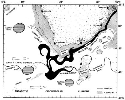
Image. Agulhas Current and Agulhas Retroflection (south of Africa) and associated
currents and eddies (from Peterson and Stramma, 1991; after Lutjeharms and van Ballegooyen,
1988).
Benguela Current
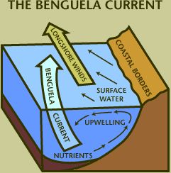
- The Benguela Current is a cold, wide current that flows northwards along the west coast of southern Africa.
- It is an Eastern Boundary Current and forms the eastern flank of the South Atlantic Gyre The ocean current “begins” roughly where the eastward-flowing South Atlantic Current swings northward at the Agulhas. Retroflection, and extends to the coast of Angola.
- It is ~200-300km wide, and typical surface flow speeds are 0.2 - 0.5 m/s (therefore much slower than the Agulhas Current), and the amount of water transported amounts to about 20 million cubic metres per second.
Upwelling
- Inshore of the Benguela Current the same longshore and south easterly winds drive a process called coastal upwelling.
- Under the influence of the Coriolis force, the winds drive the surface water offshore.
- This water is replaced by water upwelled from about ~200-300m depth, and this water is colder and rich in nutrients.
- Nutrients such as nitrates and phosphates are brought to the surface which supplies a food source for phytoplankton.
- The west coast of South Africa is particularly productive because of this process phytoplankton is at the base of the marine food chain, and therefore sustains the whole fishing industry along that part of the South African Coast. The value of the fishing industry is estimated at R2.4 billion/year.
- The east coast (Agulhas Current area) is, by comparison, poor in nutrients and does not show the same sort of upwelling as the west coast. The fishing industry is therefore confined to the west and south (Agulhas Bank) coasts.
http://www.pbs.org/edens/namib/images/map2.gif
http://www.classzone.com/books/earth_science/terc/navigation/visualization.cfm and enter Key Code ES2405 to view an animation of upwelling
Phytoplankton → Zooplankton → Predatory zooplankton → Filter feeders & Predatory fish → Marine mammals & Humans
http://www.arctic.noaa.gov/images/arctic_marine_food_web.jpg
South Equatorial Current
- The South Equatorial Current occurs in the Pacific, Atlantic, and Indian Oceans, and flows east to west between the equator and approximately 20°S.
- In the Pacific and Atlantic Oceans, it extends across the equator to about 5° N.
- In the southern hemisphere, the South Equatorial Current is the northerly flank of the large gyres in each of the ocean basins. These gyres are driven by the combination of trade winds in the tropics and westerly winds that are found south of about 30 degrees south.
- Directly on the equator, the winds reverse twice a year due to the monsoons, and so the surface current can be either eastward or westward depending on the time of year.
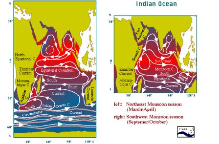
Image courtesy of Dr. Isabelle Ansorge, et al., 2009
Antarctic Circumpolar Current
- In the region of 40-60° S, the only semi-circular oceanic pathway exists that stretches right round the globe.
- This creates the opportunity for a continuous flow that passes through the Drake Passage (south of South America), traverses the expanses of the Southern Ocean south of Africa, south of Australia, and the south Pacific. This flow is the Antarctic Circumpolar Current.
- It was discovered by Edmund Halley (astronomer) in 1699.
- The ACC is driven by the westerly winds in the area, and was previously referred to as the West Wind Drift.
- The flow speeds of the ACC is 20 – 40 cm/s, but the Current is wide (500-2000 km) and deep (2000 – 4000 m). The ACC is the largest current in the world (in terms of volume transport), transporting between 100 and 200 million cubic metres per second. A value of 134 million cubic metres per second was measured through the Drake Passage.
http://oceancurrents.rsmas.miami.edu/southern/antarctic-cp.html.
http://en.wikipedia.org/wiki/South_Equatorial_Current